
Sports
Vote for Operation Football Play of the Week
By Lilith Moore
Advertisement · Why this ad?
DeAndre Washington is a lifelong Pittsburgh resident and graduate of Robert Morris University. With over 5 years of experience reporting on high school and collegiate sports for the Pittsburgh Tribune-Review, he is passionate about elevating local athletes and celebrating community pride through sports.
More from DeAndre →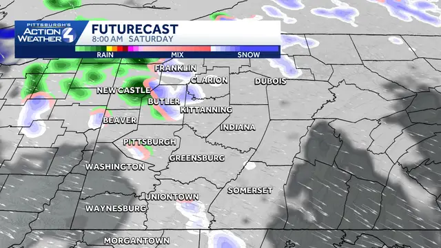
Don't blink for you'll miss the first flakes of the season.
Hearst pittsburgh: first flakes possible with a winter chill SOURCE: Hearst Updated: 4:13 AM EST Nov 14, 2026 Editorial Standards ⓘ Jill Szwed Meteorologist Don't blink for you'll miss the first flakes of the season.
The lake effect set-up turns up a bit more today with a steadier band of wet snow at times and rain stretching out north of Pittsburgh into the Laurels. It will be hard for the snow to stick for spots outside of the ridges. Outside of the wintry precipitation, this will be a blustery and chilly weekend.
A lake effect band will stretch out north of Pittsburgh and extend through the Laurel Highlands. The best chance for the majority of us to see some wet flakes is this morning through 9 to 11 a.m. A few slick spots cannot be ruled out with the freezing temperatures, but accumulations are unlikely for most of western PA.
This afternoon will bring a lull in the rain and snow activity. Grey skies will persist with feels like temperatures in the low to mid 30s. More rain and snow will develop this evening and linger through Sunday morning.
The window for snow is brief and the ground is too warm, so the snow won't stick for most of western PA. The ridges could pick up around an inch through Sunday morning, locally higher amounts are possible with upsloping.
This winter-like chill is temporary. Temperatures will reach 60° by the end of next week. Sunshine will slowly make a comeback Monday into Tuesday. Dry conditions will rule through next weekend.
TODAY: Morning flurries possible or mix, then light rain showers. High: 43°.
TONIGHT: Scattered rain/snow showers continue. :ow: 35°.
SUNDAY: Morning rain or snow shower. Cloudy and blustery. High: 46°, low: 35°.
MONDAY: Brisk with gradual clearing. High: 48°, low: 31°.
TUESDAY: Sunny and mild. High: 52°, low: 29°.
Interactive graphic shows the dramatic impact of Friday's FAA ground stop Trump administration blames 'overloaded' systems for ground stop after FAA lets flights resume QUIZ: This week in national news Microsoft apologizes for massive outage that caused global disruption
Erie, Pennsylvania
Sports
Saturday, November 14, 2026
2 min
By Lilith Moore

By Lilith Moore

By Lilith Moore
By Jason Reed